 |
|
AVHRR and VIIRS Multi-Sensor Composite |
|
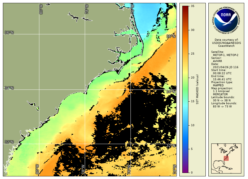
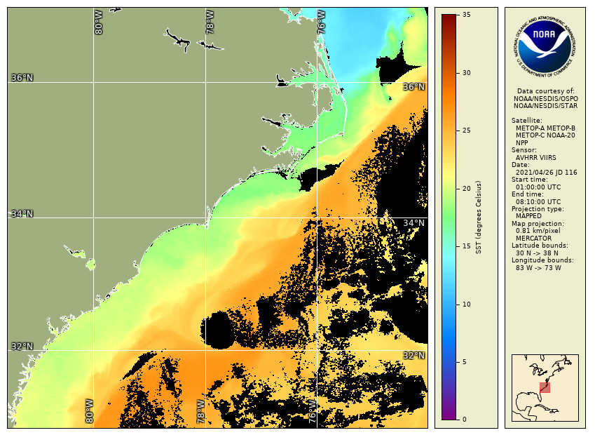
Sea surface temperature (SST) is composited into a multi-sensor combined SST product utilizing data from two instruments: the Advanced Very High Resolution Radiometer (AVHRR) on the European MetOp satellites, and the Visible Infrared Imaging Radiometer Suite (VIIRS) on the U.S. SNPP and NOAA JPSS satellites. This product offers significant improvement over NOAA's legacy operational AVHRR SST product. The single-sensor SST input data are processed consistently for both instruments using the Advanced Clear-Sky Processor for Oceans (ACSPO) processing system, incorporating an improved SST algorithm and improved quality masking. Specific notable improvements are increased SST accuracy against in-situ data, better masking of clouds, and inclusion of data at temperature fronts. Only nighttime overpasses for the U.S. east coast are used in the composite, i.e. the data do not represent daytime solar heating of the ocean surface. The NOAA legacy AVHRR SST combines both daytime and nighttime overpasses. Since the two instruments each fly on multiple satellites (e.g. MetOp-A, MetOp-B, MetOp-C for AVHRR; and SNPP, NOAA-20, NOAA-21 for VIIRS), the product includes SST input data from all satellites carrying these instruments. With two instruments and multiple satellites, the combined product has similar geographic coverage to that of the NOAA legacy AVHRR SST product. Maximizing coverage in this way compensates for the lack of daytime overpasses in this nighttime-only product. The MetOp satellites have a nighttime local equator crossing time of roughly 9:30 PM, and the SNPP or NOAA satellites have a nighttime equator crossing of roughly 1:30 AM. The combined product thereby represents data throughout the night. Data from both instruments are gridded on an 830 m earth-projected grid, close to the spatial resolution of the VIIRS instrument, thereby increasing spatial resolution over the NOAA legacy AVHRR SST product's 1.25 km spatial resolution. With this improvement, more data is included along coastlines, particularly narrow coastal areas such as small rivers and bays.
data included along coasts & at temperature fronts, improved masking of clouds and removal of bad quality data improves product's accuracy against in-situ data References: Jonasson, O., A. Ignatov, V. Pryamitsyn, B. Petrenko, Y. Kihai, 2022: JPSS VIIRS SST Reanalysis Version 3. Remote Sensing, 14(14), 3476, https://doi.org/10.3390/rs14143476 Petrenko, B., A. Ignatov, Y. Kihai, P. Dash, 2016: Sensor-Specific Error Statistics for SST in the Advanced Clear-Sky Processor for Oceans. Jour. of Atmos. and Ocean. Technology, 33, 345-359, doi:10.1175/JTECH-D-15-0166.1 Petrenko, B., A. Ignatov, Y. Kihai, J. Stroup, P. Dash, 2014: Evaluation and Selection of SST Regression Algorithms for JPSS VIIRS. Journal of Geophysical Research, 119, 4580-4599, doi:10.1002/2013JD020637 Petrenko, B., A. Ignatov, Y. Kihai, and A. Heidinger, 2010: Clear-Sky Mask for ACSPO. Jour. of Atmos. and Ocean. Technology, 27, 1609-1623, doi:10.1175/2010JTECHA1413.1 |
- See the Data Access page for data offerings by region.
- Or use Direct Download to retrieve files by time-interval and region: HTTP, FTP.
|