|
NOAA/NESDIS generates a blended sea surface temperature (SST) product that
combines data from all current geostationary and polar-orbiting satellites,
including U.S. satellites and those of international partners such as Japan
and Europe.
The higher spatial resolution of the polar orbiters (1 km spatial resolution
with observations approximately every 6 hours) is used with the higher
temporal resolution of geostationary orbiters (spatial resolution is
approximately 5.5 km with hourly observations) to generate a daily product
at 5 km spatial resolution.
This SST product is cloud-free because the SST data from the
various satellite sources are blended using an optimal interpolation (OI) data
assimilation technique. Only nighttime SST data from the source satellites
are used in the blending.
The most recent product is that of the previous day and is available by
12:45 pm (Eastern Time) on a daily basis.
Notice in the comparison below that the blending technique fills in clouds and
gaps (left), whereas a daily composite of all current AVHRR sensors
(right) still has gaps caused by persistent cloud coverage.
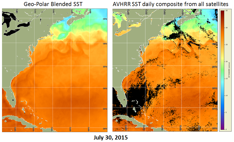
Figure: SST comparison for July 30, 2015:
Geo-Polar Blended SST (left) was generated from nighttime measurements
from: MetOp-B AVHRR, S-NPP VIIRS, GOES-East Imager, GOES-West Imager,
MSG SEVIRI, and MTSAT Imager. Spatial resolution is 5 km.
AVHRR Daily Composite (right) is the one-day average daytime and
nighttime SST from the AVHRR sensors aboard: MetOp-A, MetOp-B, NOAA-15,
NOAA-18, and NOAA-19. Spatial resolution is 1 km.
Validation of the Geo-Polar Blended SST product against one month of global
in-situ temperatures from drifting and moored buoys (33,541 match-ups
between in-situ temperature and geo-polar blended SST for the month of
December 2011) resulted in a bias of -0.03 Kelvin, a standard deviation of
0.4 Kelvin (based on mean statistics), and a standard deviation of 0.29 Kelvin
(based on median statistics). Given that the input satellite SST's themselves
had a global bias of 0.5 - 1.1 Kelvin for the geostationary satellites, and
0.4 - 0.6 Kelvin for the polar-orbiting satellites for the validation period,
the geo-polar blended SST provides improved accuracy over the various satellite
types, due to (1) the high volume of input data from the individual satellites,
and (2) the blending technique that incorporates a bias correction step. See
Harris and Maturi (2012) for further information on the blending technique and
product validation.
Reference:
Harris, A. and Maturi, E. 2012. Geo-Polar Blended SST Algorithm
Theoretical Basis Document, Version 2.1. NOAA NESDIS Center for Satellite
Applications and Research.
|