|
|
|
CoastWatch Utilities is free software for visualization and analysis of
satellite data. The Utilities include the CoastWatch Data Analysis Tool
(CDAT) and the CoastWatch Utilities Library, both available for
download in one package.
- CoastWatch Data Analysis Tool (CDAT) is a graphical user interface
for many data manipulation and visualization functions.
- CoastWatch Utilities Library is a software library of functions
that are operated from the command line. With scripts or other programs,
the library functions can preform batch processing on many files. Here is
a sampling of major functions:
- Import data in HDF and NetCDF formats.
- Export data to raw binary, ASCII text, or ArcGIS grid files.
- Render data and legends to PNG, JPEG, and GeoTIFF images.
- Perform data sampling at discrete Earth locations
(e.g. for comparing satellite data with in-situ data).
- Draw and plot data transects onto satellite data grids.
- Combine multiple data files into one composite file for
any time-step (daily, weekly, monthly, etc.).
- Calculate data statistics: min, max, mean, standard deviation,
for any file or geographic subregion.
- Perform generic math operations, including cloud masking.
- Perform satellite data georegistration to a variety of Earth projections.
- Manually apply navigational corrections.
- Obtain information on file attributes, dimensions, and variables.
|
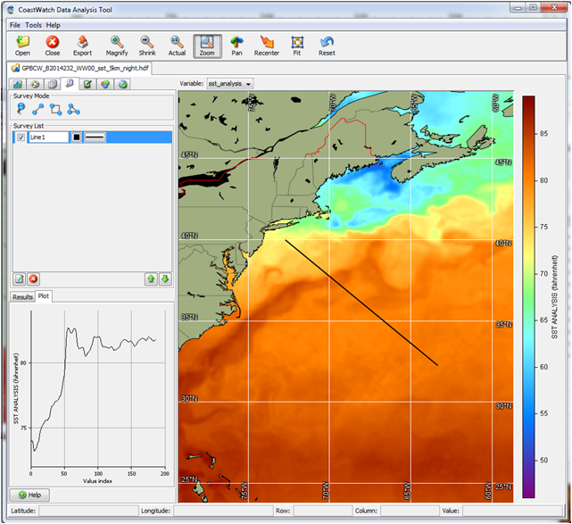
CoastWatch Data Analysis Tool
(data transect drawn and plotted)
|
Both CDAT and the Utilities Library are available in the same package,
and can be downloaded for installation on Windows, Linux, and Mac OS
platforms.
Click here
for more information and for downloading.
East Coast Node How-To
East Coast Node filenaming convention
Sample shell script to download
data from http directory tree
Latitude-Longitude file for each region
Data citation: Please acknowledge "NOAA CoastWatch/OceanWatch" when you use
data from our site and cite the particular dataset DOI as appropriate.
|