|
|
|
East Coast Node Coverage area:
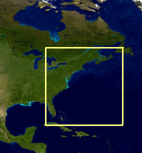
Sub-Regions are also available
Other CoastWatch U.S. Regional Nodes
Direct Download of Data Files:
Download By Satellite Sensor:
FTP,
HTTP
Download By Data Type: Data Type Info
| Sea Surface Temperature |
AVHRR:
FTP
AVHRR-VIIRS Multisensor:
FTP,
HTTP
Geo-Polar Blended:
FTP,
HTTP
PODAAC MUR:
FTP,
HTTP
|
| Chlorophyll |
OLCI (European algorithm):
FTP,
HTTP
VIIRS (OC3V algorithm, BMW atm corr):
FTP,
HTTP
MODIS (OC3 algorithm, NIR-SWIR atm corr):
FTP
|
| Remote Sensing Reflectance |
VIIRS (Rrs 672 nm):
FTP,
HTTP
MODIS (Rrs 667 nm):
FTP
|
| Diffuse Attenuation |
OLCI (European algorithm):
FTP,
HTTP
VIIRS (NOAA algorithm):
FTP,
HTTP
MODIS (standard algorithm):
FTP
MODIS (NOAA algorithm):
FTP
MODIS (NOS high-res coastal/turbid algorithm):
FTP
|
| Suspended Matter |
OLCI (All east coast regions):
FTP,
HTTP
VIIRS (Chesapeake Bay only):
FTP,
HTTP
MODIS (Chesapeake Bay only):
FTP
|
| True Color |
VIIRS:
FTP,
HTTP
|
Download By Region: Region Info
ERDDAP
ERDDAP
Data Server & Visualization/Analysis Tool
Daily Map Viewer
Event Monitoring
East Coast Node filenaming convention
Sample code to download data from HTTP directory tree:
BASH script (WGET)
Python Jupyter Notebook or R Markdown
Latitude-Longitude file for each region
Data citation & acknowledgment:
When you use our data, please reference the product citation (if available) and acknowledge "NOAA CoastWatch".
|