|
|
OLCI Total Suspended Matter (TSM)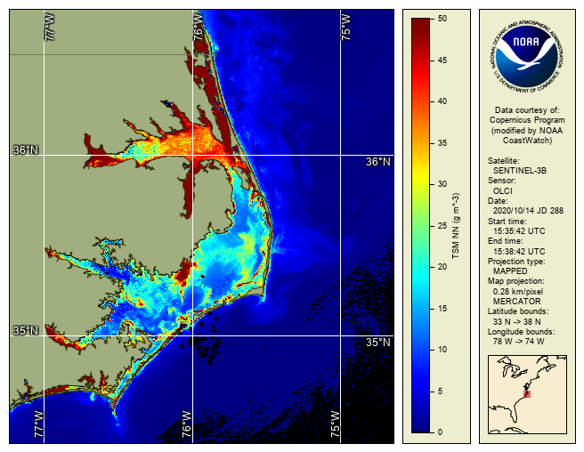
Figure: OLCI Total Suspended Matter, North Carolina Outer Banks, Oct 14, 2020, 300 m Satellite-derived total suspended matter (TSM) is a measure of the concentration of particulate material in the surface water such as mud, silt, and other fine-scale debris, including both organic and inorganic fractions. CoastWatch provides TSM products in near-real time from the Ocean and Land Colour Instrument (OLCI) on-board the European Sentinel-3 satellites, courtesy of the European Union's Copernicus satellite program. Sentinel-3 is a multi-instrument and multi-satellite mission to measure sea- and land-surface temperature, ocean and land color and sea-surface topography. The Sentinel-3A satellite was launched on 16 February 2016. Sentinel-3B was launched on 25 April 2018 with the same instruments. See the European Space Agency (ESA) Sentinel-3 website for more information. The Sentinel-3 satellites have a mid-morning local overpass time (roughly 10 AM local time). The Ocean and Land Colour Instrument (OLCI) is based on heritage from ESA's Medium Resolution Imaging Spectrometer (MERIS) instrument on the Envisat satellite, designed for measuring visible and thermal infrared radiances. OLCI has 21 bands at wavelengths from 400 nm to 1020 nm, a spatial resolution of 300 m, and a swath width of 1270 km. With both Sentinel-3 satellites in orbit, the combined swath width of the two OLCI instruments allows near global coverage to be obtained on a daily basis. Water reflectances compare well between Sentinel-3A/OLCI and Sentinel-3B/OLCI. TSM is generated using the OLCI neural net TSM algorithm (Hieronymi et al., 2017). The TSM values have been shown to compare well against in-situ values: EUMETSAT reports a 25% uncertainty for optically complex (coastal) waters (mission requirement for complex waters is 70% uncertainty). TSM is not assessed for clear waters. For more information on the ocean color algorithms, atmospheric correction, and product uncertainty, please consult the EUMETSAT Ocean Colour Service website. In particular, the Sentinel-3 OLCI Ocean Colour Processing Baseline contains periodically updated Product Notices with important quality information and the latest uncertainty assessments. CoastWatch converts ESA's TSM swath data (Level-2) into mapped gridded files (Level-3), including mapped swaths and daily composites. CoastWatch obtains the EUMETSAT operational data on a near real-time basis and has not yet obtained reprocessed collections. As such, the quality of the data as stored at CoastWatch will vary over the time series. CoastWatch East Code Node provides this data for the time period: October 2020 - present. Data Access
Reference: |
|