|
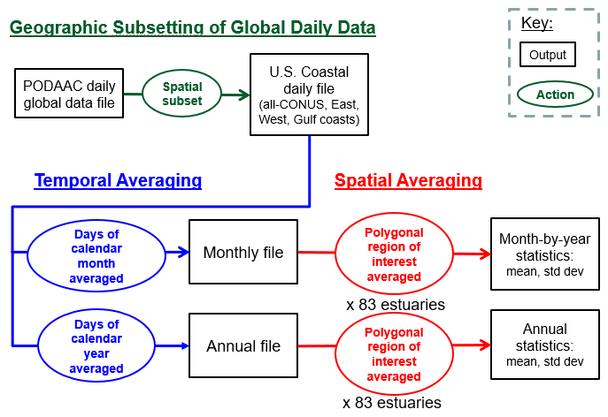
Time Series Tool
Statistics Computation
Computation method:
Description of polygon creation:
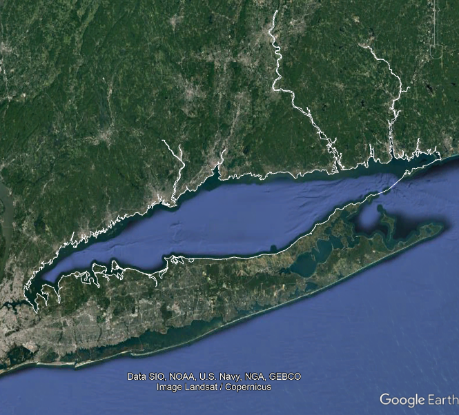
Example polygon: Long Island Sound
Estuary bounding polygons for calculating time series statistics are taken
from the EPA’s Estuary Data Mapper application.
Boundaries for large coastal regions were saved from EDM as shapefiles.
In ESRI’s ArcMap application, individual estuaries were then derived from the
regional shapefile by “selecting” polygons using the estuary name.
The selected polygons were visually checked against basemaps to verify that
they were geographically correct and the polygons were likewise checked for
contiguity.
Open water polygons which were connected by long, narrow passages or canals to
the principal body of water, may have been deselected.
EDM estuaries that were visually judged to be comprised primarily of open water
of the Pacific Ocean, Gulf of Mexico, or Atlantic Ocean were not considered
further.
Estuaries that were visually estimated to have fewer than 25, 1km×1km, clear,
open water cells were dropped from further consideration as 25 cells is the
desired statistical threshold. Quite a few estuaries that had greater than
25 km2 of surface area due to the inclusion of narrow or windy tributaries
were dropped in this manner.
The final set of selected polygons comprising the estuary were “dissolved”
to make a single polygon shapefile of the estuary. In some cases minor edits
were then applied to eliminate gaps or slivers. The dissolved polygon was
exported as a JSON and ASCII files which contain (x, y) points of (longitude,
latitude) coordinates that define the water of the estuary. EDM uses decimal
degrees and that was retained.
In a few cases the visual check of EDM boundaries revealed that those
boundaries were not the best way to represent the estuary. This occurred where
estuary boundaries were:
- excessively complicated due to doughnut holes or the inclusion of many
minor tributaries
- were large and would have a corresponding large number of EDM polygons
- were in Louisiana where the land/water boundary of some estuaries was
difficult to clearly determine.
In those cases a HUC water feature polygon that was well matched with the
target estuary area was used instead of the EDM polygons.
Estuary selection priorities:
Estuaries included in this tool were selected accoring to these criteria:
- estuaries large enough to have enough open water satellite cells to pass
statistics thresholds
- associated with populated areas, e.g. are near a sizable city
- National Estuary Programs usually met the above two criteria because they
are “estuaries of national significance,“ and they are included
based upon those two criteria if they did
- smaller (close to the statistical threshold), rural or remote estuaries
were included if they passed the polygon creation steps
About NASA PODAAC MUR Sea Surface Temperature:
|